» Uncategorized » Climbing Hayes Peak in the Sierra Estrellas
Climbing Hayes Peak in the Sierra Estrellas
NOTE: This post has nothing to do with law. I’m not even going to try to make it relevant to my practice. If you don’t care about how to hike the highest peak in a rugged and desolate mountain range that towers above Phoenix, this probably isn’t going to be very interesting at all. I’ll post something law-related for you soon.
The Sierra Estrellas
Phoenix is surrounded by mountains, and the Sierra Estrella range has to be one of the most impressive. Many evenings, I get to see the sun set behind them as I drive home from the office. Although I’ve been looking up at the Estrellas every day for years, like many people, I had never ventured into the Sierra Estrella wilderness until very recently.
My friend Andy and I climbed Quartz Peak this past spring, and we both left wanting to someday climb the range’s highest point, Hayes Peak. The idea of another Estrella excursion soon faded from my memory, but not from Andy’s. He did all of the planning, and we decided to climb Hayes Peak a few weekends ago.
Of all the peaks, Quartz is the only one with a real trail going to the top. It’s a great hike, and there are plenty of websites telling you how to do it. Aside from reports on the trial to Quartz Peak, however, there’s generally a dearth of good information on the Estrellas. Even the names of the peaks aren’t so clear, though John Arthur does a good job identifying them here.
When it comes to Hayes Peak, someone who goes by “surgent” put up this good resource for the hike, and this page on surgent.net (which I presume is surgent’s site) provides a good narrative about one way to the top. We relied on those sources to figure out how to get there as well as how to get to the top.
The Drive
The Estrellas may be close, but there’s no good way to get there because it’s bordered to the East by the Gila River Indian Community. Unless you want to commit civil trespass (how’s that for tying this in to the law!), you’re going to have to go all the way around the range and climb it from the West.
We took the I-10 West to Sierra Estrella Parkway and took that South until Elliot Road. We turned right on Elliot Road and followed that until Rainbow Valley Road, where we turned left to follow it South to Riggs Road. We turned left on Riggs Road and followed that East until it came to a “T.” At that point, Riggs Road actually continues East in a straight line more or less, but it’s offset slightly to the right at the “T” and it’s a primitive dirt road from that point on. Hang a right and an immediate left onto the dirt portion of Riggs Road after the “T.”
The road is actually pretty good until you pass a cattle guard. After that, it’s pretty sandy and washed out at times. Adrian and I once went out there on some Kawasaki KLRs, but we turned back in search of more entertaining, less sandy roads. Follow the sandy dirt road until you hit another “T.” Here’s the route up to that point marked on a map:
At that “T,” hang a left. You would’ve gone right here to get to the Quartz Peak trail head. Take the road north as it follows the power lines. It’s a little hard to see, but you’ll come up to an intersection after a little while. Apparently, this is Ocotillo Road coming in from the West. You want to go East, so hang a right. From what I can recall, it’s the first thing on the right that looks much like a road at all, and it’s after what appears to be a turnoff on the right. Go a short distance until you see a little fire ring made of rocks. This is where you’ll park.
The Hike
We basically took the red route to the blue route to the speculative green route on this map (from surgent):

Here is Andy’s own map of our exact route:
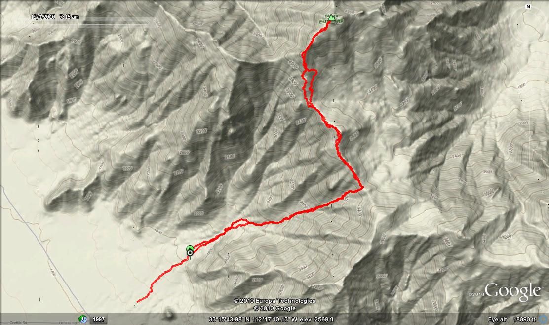
When you first get to the fire ring, you will see a bit of a path heading into the mountains, which you can follow for a few minutes before it disappears. You will have passed a little hill of sorts to the Southeast of where you parked. At this point, you’re basically on your own. There is no trail, but you’ll be in the wash you’re going to follow for a large portion of the hike. Follow it past a ridge that will be to the Southeast of you and that runs more or less East to West. Here’s the view near the beginning of the hike:

You can see a knob on the ridge above the center of the boulder in the picture. You basically follow the wash as you aim for ascending to the ridge line to the right of that knob. We stayed on the left side of the wash, which mostly avoided cliffs and other insurmountable obstacles. The route will get very steep as the elevation increases. The toughest part of the hike is probably the last little scramble to the ridge line, where the ground is loose and it’s extra steep. It’s all steep, but that stood out to me.
When we finally reached the ridge line, we were treated with this view as we looked West and surveyed the way we’d come:

You can see the little hill near where we parked (to the left of center) as well as the first ridge we passed following the wash (the one that goes almost the the center, starting from the left). If you follow the right tip of that ridge straight up until you’re even with the middle of the little hill, you can see the where the vehicle is parked.
Before reaching the ridge line, you won’t be able to see Hayes peak at all. After the ridge line, the hike is nothing but great views, and you can clearly see your goal. Here’s the view from the ridge line approaching the summit:

We found that following the ridge line all the way to the peak, including all of its ups and downs, wasn’t a bad way to go. The only problem was the fact the peak looked so close for so long. It was really discouraging to have to drop down again and again. When you finally get near, however, you realize the antenna you were seeing on top is much larger than you probably expected. The top of Hayes Peak is covered with solar panels, a shed, and an antenna. Here’s what you see when you arrive:

Here’s the view looking North from the summit:

Here’s the view of the Phoenix metro area from the top:

Zooming in, you can see the city:

You really get a sense of how big the Estrellas are when you look down on South Mountain, which appears to be more of a mound or a hill than a mountain from above:

Looking South, you can see the other peaks in the Estrellas:

The terrain is rough and steep, as you can see here:

To get down, just follow the same path you came. You will likely be able to see your vehicle for most of the hike along the ridge line, which actually ended up being a little disheartening for me. It looked so tiny for so long that I felt we weren’t making any progress.
In the end, it wasn’t that much faster going down than it was getting up, if it was faster at all. We also had a close call with a rattlesnake hiking down. Andy stepped onto a rock and we heard some serious rattling coming from a crevice behind where he stepped. That sure got the adrenaline flowing.
Overview
In general, the route we took seemed ideal. We left my house in the East Valley at 5:00 a.m. and started hiking around 6:45 a.m. We reached the top around 10:30 a.m., enjoyed some snacks and a lot of water at the top, and got back to the vehicle by 2:30 p.m. I was back home shortly after 4:00 p.m. All in all, the hike ended up being just over 7 miles from the vehicle to the top and back. The total elevation gain was 3,082 feet, starting at 1430 feet and topping out at 4512 feet.
For anyone hoping to do an unusual hike with no trail in a beautiful, remote wilderness area right next to Phoenix, you really couldn’t ask for anything more.


Filed under: Uncategorized · Tags: climb, hayes peak, hike, mountain range, sierra estrella, wilderness
20 Responses to "Climbing Hayes Peak in the Sierra Estrellas"
Leave a Reply to Sean Cancel reply


Having grown up in the Tolleson area north of the Estrella, I was always mesmerized by the beautiful Estralla range. In 1975 and again in 1976, I organized a couple of high school friends to climb the highest peak from the Gila Indian Reservation side. We had a friend drop us off somewhere south of 91st Ave and Baseline. We hiked due south and headed up a steep ravine toward to the summit. It was a full day of of serious scrambling and fighting off the cat claw as the north side of the Estrella’s is heavily vegetated, unlike the barren south side. We spent the night about 3/4th of the way up the mountain near a small cave that had a dead bighorn sheep in it. As this was before cell phones, we used a flashlight to ‘blink’ acknowledgement back to my house south of Tolleson at a prearranged time that we were safe. My dad blinked a powerful flashlight back to us that he received our signal. We summitted the next morning and spent a few hours enjoying the view and hiking around the antenna site. We descended the same ravine. Best hike I ever did in Arizona!
(Part Two)I will say the journey was successful, but this hike is not for the average Joe! It will take every last ounce of energy you have and then some. This place looks more like Afganistan than Arizona. And no I’m not in the Military I’m just making a point. I took the green route up and the blue route back, and its very strenuous! I started around 7:15am got to the Summit around 11:25 stayed at the summit for about 15min then turned around and went right back down got back to the truck at exactly 3:00pm! The way up I took no breaks other than catching my breath about every 30ft or so. On the way back I took about ten. It was a lot harder going down for me than up and very hard on the knees! Youll have a better understanding of what I’m talking about if you dare try it! All it is is boulder hopping the whole time, I tried putting some rocks up as I went to mark the trail but I was difficult! You just have to use your good judgement. Remember only take what you can use and carry nothing more! Cause what you take up you have to bring back! I took a backpack with a sweater, a large Gatorade one bottle of water, and a first aid kit and believe me that was enough! I had a small digital camera in my pocket and a cell in my other pocket! I had ripstop cargo pants and 8inch desert combat boots on and I’m glad I did! there is rock, bushes and twigs and cactus galore not to mention Rattlesnake City! I would not recommend trail running shoes or shorts! to much debris remember there is no trail you have to just find your way. Hope this info helps.
good luck!
Sean
(Part One) Iv’e been living in AZ all my life and had always wanted to climb this Mountain, and about four years ago after we moved to Laveen I made that attempt but failed! So last Sun I decided to go for it, and was successful! So I read this post above, wrote it down on some junk mail and went for it! Left my house around 5:30 stopped at Safeway on Estrella Pkwy got some goodies took Pkwy to Willis then Willis to Rainbow Valley, Rainbow Valley to Riggs, Riggs to Power line Rd then took a left went about 2 mi to Ocotillo then right to the campsite next to that fire ring and parked the truck at about 7:10am. I had no GPS and it was perfect. Riggs was paved most of the way but after the cattle guard it did get a little sandy, I would recommend a high profile vehicle or 4WD though!
So, just out of curiosity….what’s the penalty for the Civil Trespass you mentioned? I recently had a run in with that, quite by accident, myself…who knew when the paved road just stops but the dirt road continued that you were supposed to stop also?!
PRETTY SURE THAT I AND A FRIEND WHEN THE BLUE WAY IN 11-11-2006. VERY STEEP UP TO THAT SADDLE. THAT HIKE IS TOUGHER THAN HIKING THE GRAND CANYON. BEST HIKE IN THE STATE!
Would love to see the photos of the hike if you are able to restore them.
Question: I lead groups for a local hiking club, and I would love to place this on the calendar, however I am curious to know if this is allowed and are you sure this is not Indian Reservation Land. Is the access point on Indian Land, or BLM Land or State Trust Land or Private Land? I am just curious to the logistics of the hike and if they are kosher to admit taking in the hiking community? I really want to do this hike, but am a little apprehensive as I do not want any legal trouble. I would sincerely appreciate your details and opinions.
The access point is not the issue – the top apparently belongs to the Gila River Indian Community, so it is technically trespass to be up there. Some of the sites I link to explain the situation at greater length.
Thanks MAtt. Can you send me those links? I want to place this on my calendar for January.
All the links are in the post.
Great post. My parents live in Estrella and I have often wondered the best approach since there is no good way from North or East. Question: Did your cell phones work along the way?
Thanks again for the nice post,
-Michael
Reception was spotty at best, even on top. Not sure why, given the proximity to millions of people and all…
To reply to the cell phone question, your phone is receiving just fine…hundreds of signals simultaneously! That is, your phone is being jammed by receiving all the base stations at once–and, conversely, all the cell sites receive you simultaneously. This is a big part of why the FCC and cell companies don’t like (widespread) cell phones on planes, though a microcell on board would fix this.
Forgot to mention, I’m a ham radio operator, and have been wanting to put something on this mountain from the first day I got to Phoenix, but have been warned off by those who know better due to the helicopter-only access. (I do NOT live in Snotsdale and am not rich!)
I was wondering if you still had the Google Earth path map that you could send me so I can enter it on my gps to follow the route?
It should be loading above again. Is it not? Or do you mean something else?
I think he’s looking for the actual data so he can enter it in his GPS, which would require the information from Google Earth. However, I used a GPS which created its own map and then superimposed it in Google Earth, so there isn’t any data that can be extracted from Google Earth to be programmed into another GPS.
Really, though, it shouldn’t be necessary when there are two different topo maps showing the way.
I’d say it all depends on their experience level with route-finding, especially their ability to get back to the vehicle.
Would you suggest this as a hike for two 18 year old boys who like to hike on a spring day? OR is this for the more experienced hiker looking for a trail-less challenge? Would you allow your son to take this hike, if you have one?
Concerned Mom
DID YOU HIKE IT?